About Us - Pocket Pals Trail Maps, Colorado Trail and Recreation Maps
Developing detailed and up-to-date trail maps for Colorado.
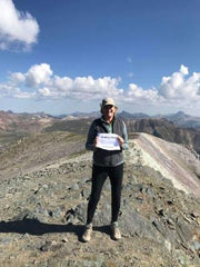
Hi I'm Julie and I started POCKET PALS Trail Maps in 2011 to better address the needs of hikers, mountain bikers, runners, backpackers and equestrians by developing detailed and up-to-date trail maps for Colorado. I am passionate about Colorado's gorgeous outdoors, it nature and especially its trails. In fact, I met my husband on a trail (now that's a story!....but a little too long to go into here).
Why did I start POCKET PALS Trail Maps? How many times have you been anticipating an exciting new adventure on the trails of Colorado and you can't locate the trailhead? Or you arrive at a trail intersection with no way of knowing which way to go in order to get to your desired destination? OH...and what about taking those cumbersome trail guide books or large over-sized maps in and out of your backpack over and over again during your trip? Or when you make a paper copy of a map and/or it's textual description prior to hitting the trails and and after a little sweat / rain or folding and unfolding this paper map a few dozen times it literally ends up falling apart! Believe me, during all of my trail adventures through the years these types of things happened to me all too often. That is when I decided that there really needs to be better trail maps for Colorado" (the outdoor recreation mecca of the U.S.)! Trail maps with more detailed and accurate trail information that are better made, more portable, and water-proof and tear-resistant. And Voila!......that is how POCKET PALS Trail Maps was formed! It also helps that I have a true passion for hiking Colorado trails and have a background in cartography and Geographic Information Systems. In fact I have been collecting Colorado trail data (using my handy GPS units) for over fifteen years now! And I am always working on new maps to expand our product line!
Based in Colorado Springs, Colorado, along the Front Range of the Rocky Mountains, POCKET PALS has produced the premier trail maps for Colorado. Unlike other trail map websites, trail books or trail map vendors, POCKET PALS obtains its trail information using a field Global Positioning Satellite (GPS) device out on the trails to accurately locate the trails and other significant landmarks (waypoints) along the trail. Our cartographer (that's me) then uploads this data onto our detailed, digital base maps to produce the finished product.
Give my trail maps a try.... you will be glad you did!
If you have already been using my trail maps....THANKS!... and please let me know what you think of my products by writing a review on any of our product pages.
Thanks!
And Happy Trails to All!
Julie