Buffalo Creek Recreation Area - Trail Map
The Buffalo Creek Recreation Area (BCRA) lies within the Pike National Forest.

The Buffalo Creek Recreation Area (BCRA) is located just north of Deckers, Colorado on County Rd. 126. The BCRA is 55 miles from Denver, 50 miles from Castle Rock and 66 miles from Colorado Springs. This recreation area contains 67 miles of trails (21 trails) and many camping areas. This map also includes detailed trail data and information on the amenities available for Jefferson County's Pine Valley Ranch Park (just north of the BCRA).
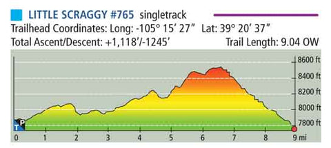
This map contains detailed information for all 21 trails within the BCRA including trail length, trailhead coordinates, total ascent/descent, trail rating, elevation profiles, and if the trail is single or double track. It also includes contour lines at 60-foot intervals and a longitude/latitude grid.
This map will fit conveniently into your pocket, it is 3.8" wide and 6.25" tall (when folded) and is 19" wide and 12.5" tall when unfolded. It is also completely waterproof & tear-resistant.
Two formats are available: water-proof & tear-resistant paper or digital (GeoPDF). Learn More Here
A sample of the trail data provided for each trail.


