Buffalo Creek Recreation Area - Trail Map
Explore one of Colorado’s premier trail destinations with the Buffalo Creek Recreation Area Trail Map. Located just north of Deckers along County Road 126, the recreation area offers approximately 67 miles of trails, developed campgrounds, dispersed camping opportunities, and access to a wide range of outdoor adventures.
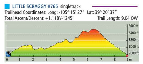
The map includes detailed information for all 21 trails within the Buffalo Creek Recreation Area, including trail distances, trailhead coordinates, total ascent and descent, difficulty ratings, elevation profiles, and singletrack or double-track designations. It also features 60-foot contour intervals.
Coverage also includes nearby Pine Valley Ranch Park, with detailed trail information and available park amenities. This map is especially useful for mountain bikers, hikers, trail runners, equestrians, campers, and other outdoor enthusiasts.
The Buffalo Creek area continues to recover from several major wildfires, including the 1996 Buffalo Creek Fire and the 2002 Hayman Fire. As a result, portions of the recreation area remain more open and less heavily forested than they once were, offering expansive views but greater exposure to the sun.

Available formats include:
Paper Map – Pocket-sized, waterproof, tear-resistant, durable, and easy to carry on the trail.
Digital Map for the Pocket Pals Map Viewer – Designed for offline use after download, with the ability to view your current location on the map when using your phone’s location services.
To learn more about our digital maps and the Pocket Pals MapViewer, CLICK HERE.
A sample of the trail data provided for each trail is shown below.