


Pikes Peak Area Trail Map - Pikes Peak Region, Map #7
The trails on Map #7 are located along the western flank of Pikes Peak, directly south of Divide, Colorado.
This map covers trails within the Pike National Forest and the Catamount Ranch area, offering access to a scenic network of forested routes, mountain terrain, and outdoor recreation opportunities (including hiking, mountain biking, trail running, and horseback riding (where designated).
Map #7: Pikes Peak Area includes the trails listed below. Click any underlined trail name to learn more about that trail.
- Crags (Trail 664)
- Elder Fehn
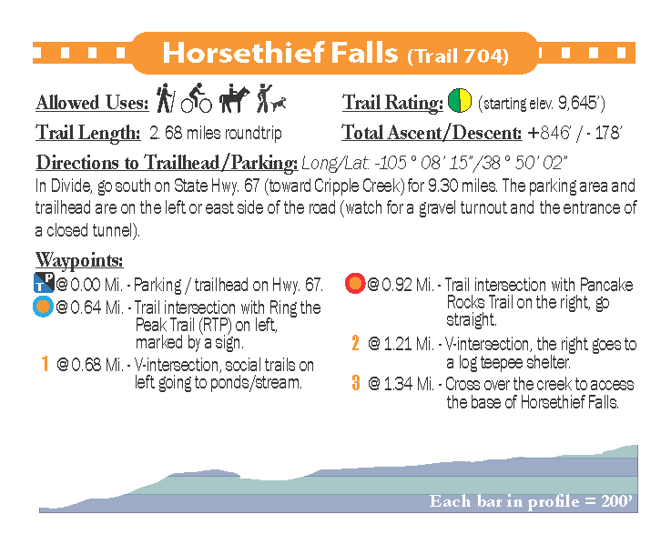
- Horsethief Falls
- Pancake Rocks (RTP) 704
- Devil's Playground (Trail 753) - formerly Trail 664A - to Pikes Peak's summit
- Raspberry Mountain
- Ring the Peak (RTP) - Segments 4-5, 5-6, 6-6A
- Sentinel Point
- Vayhinger
Available formats include:
Paper Map – Pocket-sized, waterproof, tear-resistant, durable, and easy to carry on the trail.
Digital Map for the Pocket Pals Map Viewer – Designed for offline use after download, with the ability to view your current location on the map when using your phone’s location services.
To see an overview map of our Pikes Peak Region series, CLICK HERE
To learn more about our digital maps and the Pocket Pals MapViewer, CLICK HERE.